BRIEF GEOGRAPHY
A BRIEF GEOGRAPHY OF M’MOCKMBIE
Found in Alou Subdivision, Lebialem Division, South West Region of Cameroon, M’mockmbie Kingdom is located between longitude 9°55 and 10°01 East, and from latitude 5°35 to 5°39 North of the Equator as presented on the figur.
Figure 1 presents the location of initial villages in M’mockmbie Kingdom. M’mockmbie Kingdom is bounded to the North by M’mockngie, Bechati and Bamumbu Fondoms, to the South by Nwangong and Leleng Fondoms, West by Besali and Bangang villages, and to the East by Fongo-Tongo in the Western Region. M’mockmbie Kingdom covers a surface area of approximately 74km2 with population density of 355 inhabitants/square kilometre in 2020. According to population Census (1976), M’mockmbie Kingdom had a population of 2509 inhabitants which increased to 4573 in 1987 (Population Census, 1987). It was projected to be 8,347 in 1999, 2005 (11,590), 2010 (15,236), 2015 (20,029) and 27,986 in 2020. It is estimated to reach 34,613 by 2025, 2030 (45,502) and 59,817 in 2035 (Nnecdem P., 2021). This population is spread over a rugged relief (figur


RELIEF AND GEOLOGY
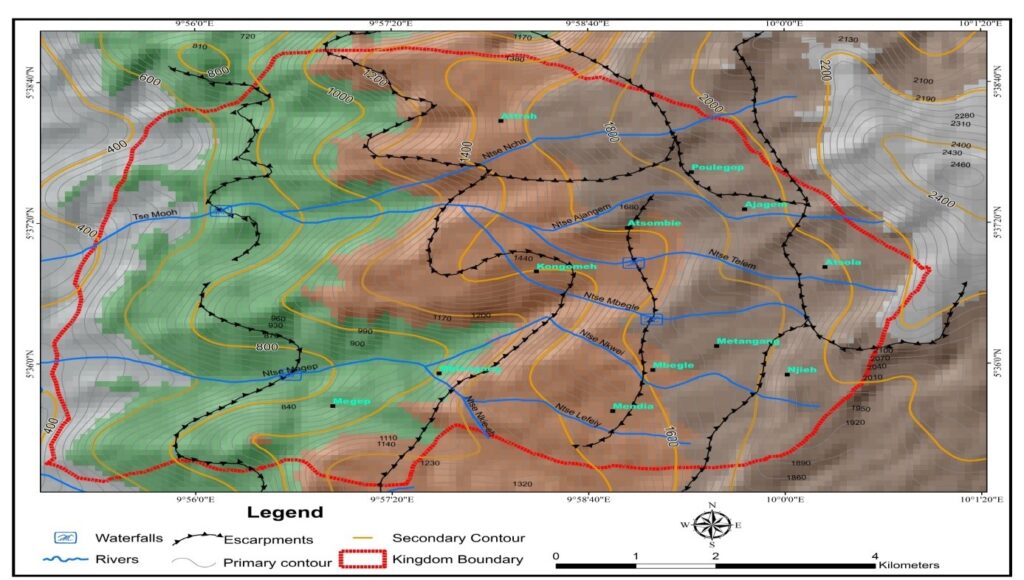
Figure 2 illustrates the relief of M’mockmbie Kingdom. It shows steep slopes and escarpments. The relief of M’mockmbie Kingdom is divided into the Lower, Middle and Upper Belts. Height in the Lower Belt ranges from 400m to about 866m with an average height of 688m. Height in the northwest of the Lower Belt is 800m, northeast (866m) and southwest (400m). Efem Atsombie, Efem Kongomeh, Efem Mendia, Efem Mekang and Efem Atieh are some localities found in the Lower Belt.
The Middle and Upper Belts are not quite different. Height in the Middle Belt is between 866m-1300m with an average height of 966m. Attrah and Apo-le-gop, Kwaah, Kongomeh, Mbegle, Atsombie, Mendia and Ajangem are quarters located in the Middle Belt. Height in the Upper Belt ranges from 1300m to 2233m with slope gradient of 37°. The highest spot height in the Upper Belt is on Mount Tsonkeng (2233m). Average height in the Upper Belt is about 1766m. Atsengatoh, Njieh and Atsola quarters are located in the Upper Belt of M’mockmbie Kingdom. The Lower, Middle and Upper Belts can also be grouped into the Western Lowlands (Lower Belt) and Eastern Highlands (Middle and Upper Belts). The north easting flank of the Kingdom is linked to the Bamboutos Mountains with Mount Tsonkeng rising to 2233m above sea level. From the Lower to the Upper Belt, the trend of the land is from East to West. The relief of M’mockmbie Kingdom is a reflection of its geology as seen on figure 3.
At the foot of escarpments, there is leucocratic granite of igneous rock. The igneous rock located west of the kingdom is light in colour and contains close to 90% felsic minerals producing relief ranging from 800 to1340m. Above1400m, the rocks are different, originating from volcanic eruptions in the Western Highlands of Cameroon. According to Peronne (1969), the earliest basaltic eruptions in the Western Highlands started from the end of the Cretaceous and continued into the Tertiary period. The basalt has a basalto-andesitic composition: fine-grained with phencocrytes of olivine and augite in a matrix of microlites, olivine, ore and volcanic glass. It is also dark grey or black in colour. The basalt forms lava plateau with altitude generally above 1400m (Peronne, 1969). The northern part of the kingdom is connected to the Bamboutos Caldera in the Western Region. It is made up of volcanic, basaltic and trachytic rocks. Trachyte is more acidic volcanic rock containing feldspar and some quartz. The outstanding peak produced by volcanic and trachytic rocks is Mount Tsonkeng (2233m), an ecotourism potential not well known to boost the tourism sector of Cameroon.

Nwangong, Besali and Bechati. During bright weather, part of Dschang town in Menoua Division is also visible from the summit. Apart from a wonderful panoramic view, the eastern slope of Mount Tsonkeng has a rolling topography while the southern slope is concave due to basaltic rocks. This eastern slope is exploited for the cultivation of cash and food crops such as Irish potatoes and cocoyam. Vegetables such as carrots, leaks, and cabbages are also grown in this area. To the North North West of Mount Tsonkeng, there is a cliff produced by trachytic rock. In addition, Toh Tsonkeng and environs provide an exceptional relief for the reception of communication network signals.
Toh Tsonkeng has a mysterious past. The stories told about this mountain were either uncanny or interesting to the listener. Apart from being considered as home for witches and wizards, the people of the kingdom thought Toh Tsonkeng produced fire which lighted the village every day for close to nine (09) days. Others held that the ‟mysterious fires” occurring during the dry season were set, mastered and used by the King and his traditional society of nine (09) strong members during their evil gathering. With this mystery in mind, people were sceptical to move close to the mountain in the dry season. The myth was broken when the indigenous people understood the seasonal bush fires were set by herdsmen in preparation for new pasture to graze their cattle. Apart from Mount Tsonkeng, other spectacular ecotourism potentials in the kingdom are tors and caves.